5 days in Le Marche

    Cingoli, Frasassi and Conero

    Hills, caves and two days on the Conero.

    Hills, caves and two days on the Conero. A day-by-day programme with time for visits and travelling between areas.

    Cingoli
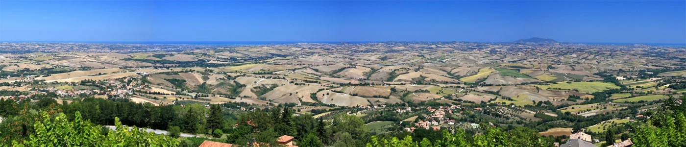
    Photo: Alessandro Vecchi · Wikimedia Commons
    Time
    5 days · with breaks
    By Car
    161.7 km approximately
    On foot
    11 km approximately
    Pace
    Slow · visits and walks

    The Trip at a Glance

    Stops and distances

    Map of the stops · Nights 1–2 inland; nights 3–4 towards the coast

    Car transfers

    Driving Distances and Travel Times
    SectionKmTime
    Day 2Cingoli
    towards Treia
    20,3~24 min
    Day 3Treia
    towards San Vittore di Genga
    59,2~58 min
    Day 3San Vittore di Genga
    towards Jesi
    34,5~31 min
    Day 4Jesi
    towards Sirolo
    46,3~47 min
    Day 5Sirolo
    towards Numana
    1,4~3 min
    Total between areas161,7~163 min

    Turquoise line: road connection between areas. Times exclude traffic, stops and searching for parking. Return journey, accommodation and detours excluded. Numbered markers indicate the areas visited: they are not exact entrances or a hiking track.

    Directions to the first area

    Walking: around 11 km during visits. These are walking estimates: they vary with parking, detours and chosen admissions. Distances from specific sources are identified in each stop.

    A Programme to Adapt to Your Pace

    Your journey, day by day

    The suggested times organise the route: confirm venue opening times. For lunch and dinner, choose among the local alternatives rather than adding them all to your schedule.

    Day 1

    Cingoli
    1

    Day 1 · 10:00

    Cingoli, the Balcony of Le Marche

    3–4 h including lunch · ~2 km on foot

    Start with the town centre and views over the hills. Keep the afternoon for a local visit chosen on the day: the first day does not require a long transfer.

    Leave your car outside the centre and check restricted traffic zones, opening times and access. The map point identifies the visit area, not the exact entrance.

    Day 2

    2

    Day 2 · 10:00

    Treia and the hillside landscape

    3–4 h including lunch · ~2 km on foot

    Devote the day to the village and squares, alternating walks and breaks. A business visit is optional and must be arranged in advance.

    Leave your car outside the centre and check restricted traffic zones, opening times and access. The map point identifies the visit area, not the exact entrance.

    Day 3

    3

    Day 3 · 10:00

    Frasassi: guided visit

    75 min + access and break · ~1,5 km on foot

    Book the tourist cave visit and plan your arrival following the operator’s instructions. Do not automatically add speleological routes to the standard ticket.

    Leave your car outside the centre and check restricted traffic zones, opening times and access. The map point identifies the visit area, not the exact entrance.

    4

    Day 3 · 15:30

    Jesi, squares and palaces

    2 h · ~1,5 km on foot

    On the way to the coast, choose a stroll through the centre. Any cultural admission depends on opening hours and time remaining.

    Leave your car outside the centre and check restricted traffic zones, opening times and access. The map point identifies the visit area, not the exact entrance.

    Day 4

    5

    Day 4 · 10:00

    Sirolo, village and viewpoint

    A day with breaks · ~2 km on foot

    A relaxed day on the Conero: town centre, views and a beach reached only by authorised access. A boat trip must be booked separately.

    Leave your car outside the centre and check restricted traffic zones, opening times and access. The map point identifies the visit area, not the exact entrance.

    Day 5

    6

    Day 5 · 10:00

    Numana and the sea

    Half day · ~2 km on foot

    Finish with the village and a coastal walk. Keep the afternoon free for the journey home, without adding Gradara to this route.

    Leave your car outside the centre and check restricted traffic zones, opening times and access. The map point identifies the visit area, not the exact entrance.

    The stop is part of the journey

    What and where to eat

    Hill-country cuisine, Verdicchio and Adriatic seafood.

    Editorial alternatives, ordered by location and name, with equal visibility. There are no sponsored placements in this selection. Confirm opening times, menus, prices and availability directly; meals are not included.

    Before setting off

    Parking and Getting Around

    A car is recommended. This trip uses different bases, so plan it to avoid unnecessary journeys. Map points identify areas: ask about parking and actual access to venues. Distances exclude the return journey, accommodation and detours.

    Admission, bookings and budget

    Confirm tickets and time slots directly with operators. Lunch, accommodation, parking and any guides are charged separately; none are included. Nights 1–2 inland; nights 3–4 towards the coast.

    Season and alternative plan

    For Due Sorelle, check authorised access and sea conditions. Visiting and winery opening times require confirmation.

    Where to stay. Nights 1–2 inland; nights 3–4 towards the coast. Journeys from your chosen accommodation must be added to the distances between stops.

    A tip from Giando

    Leave room for an extra stop.

    Choose one fewer visit and one extra break. The suggested schedule leaves room: if you find an interesting event, replace a stop rather than adding it to the programme.

    Discover events along your journey

    Questions before you set out

    Do I need a car?

    A car is recommended; this journey has different overnight bases, so plan to avoid unnecessary transfers.

    How many kilometres are included?

    161.7 km by car between areas and around 11 km on foot during visits. Walking distances are editorial estimates, except where attributed to in specific source; excluded alternatives are not included in the total.

    Are the times guaranteed?

    No: these are suggested time slots to plan your trip. Confirm official opening hours, admission slots and access before setting out.

    Is it suitable for a pushchair?

    This itinerary is not certified accessible: historic centres, slopes and uneven surfaces may require adjustments. Ask operators and skip unsuitable sections.

    How Do I Choose Where to Eat?

    The entries offer alternatives along the route, ordered by locality and name. Confirm opening times, menus, prices and availability directly.

    Keep Marcheggiando

    Sources, images and latest check · 13 October 2026

    Driving routes calculated with OSRM using OpenStreetMap; indicative connections between areas, excluding return journeys and accommodation. Walks are estimated unless a distance is attributed to a source at the stop. Check conditions before setting off.

    Photo: Alessandro Vecchi · Wikimedia Commons. Credits for the freely licensed photographs used on this page:

    cingoli · Alessandro Vecchi · CC BY-SA 3.0 · converted to WebP and cropped for display.